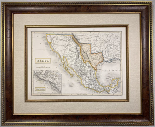
Original Map of the State of Texas, circa 1876
approximately 21″ wide x 18″ tall”
Contact the gallery for preferred pricing and details on our custom archival framing services for fine original maps and documents.
$1,250.00
Original Map of the State of Texas, circa 1876
approximately 21″ wide x 18″ tall”
Contact the gallery for preferred pricing and details on our custom archival framing services for fine original maps and documents.
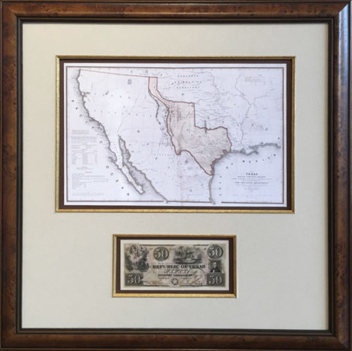
The Texas and Pacific Railway Company was the only railroad in Texas, and one of the few in the United States, to operate under a federal charter, granted in 1871. The Texas and Pacific was given the right to lay track from Marshall, Texas, to San Diego, California and played a crucial role in the expansion of the vital young state. Texas fascinated people across the United States and overseas looking for new opportunities and a chance for a better way of life in the rich vast lands of the legendary southwest.
This fine pocket map was published and distributed to promote the routes of the Texas & Pacific Railway Company encouraging Texans to explore their expansive and diverse home state as well as offering an efficient connection and a more direct route to explore the untamed lands out West. The dotted black lines show the established railways mainly in the more developed eastern half of the state, connecting the capital city of Austin with various commercial centers like Houston and the port of Galveston down south and Fort Worth and Dallas up north. The solid black lines represent proposed or under construction tracks, mostly across the vast expanse of west Texas where the land was reserved in anticipation of the completion of the transcontinental railroad. A table in the upper right corner shows distances between Texas cities connected by the Texas and Pacific railroad.
Details on this captivating map include cities, towns, counties, military posts, roads and various railroad lines across Texas connecting with the Texas & Pacific. Many natural features for prospective visitors and settlers are listed, especially along the proposed route out west, like springs, mountains, lakes and timber forests. Greer County in the south east panhandle is part of Texas – the disputed land would later belong to the United States via a Supreme Court Ruling. A highly detailed Indian Territory in present day Oklahoma is included naming all the tribes and their locations. The Texas and Pacific track runs beyond east Texas to Shreveport LA and Hot Springs Arkansas connecting Texas to other railways running across the United States. This fine promotional map is a detailed portrait of Texas in the early days of the railroad empire highlighting the dream of westward expansion that would define the United States. Railroads would eventually rule the lands for the next 70 years providing the most prevalent form of transportation across Texas and the United States until the 1940s – providing a comfortable and efficient means for conducting business and enjoying leisure travel in the legendary Lone Star State and beyond.
Our framed selections are individually hand-crafted to order. As such please allow approximately two weeks for most items to ship. Please call (512) 472-7701 or email li**@ga******************.com to discuss in-stock items or expedited availability.
We can ship selections all over the world, usually by FedEx. Everything is expertly packed and fully insured. FedEx charges vary depending upon distance, package size and shipping speed; please call or email us for specifics.
Generally, the shipping cost of a full scale flag runs between $45–$75. Most other framed items, including collector size flags and map replicas can be shipped for about $35.
As often as possible within Texas we try to deliver your order on our truck. This is especially true if you are getting several items at once.
We usually visit Houston, Dallas and San Antonio every couple of weeks, and special deliveries can be arranged as needed. It is our pleasure to try and personally deliver within Texas when possible.
FREE SHIPPING ● Give us a call (512) 472-7701 ● Send us a note lisa@galleryoftherepublic.comJoin our quarterly newsletter and receive special offers! We’d like to introduce you to the rich heritage of Texas! Dismiss