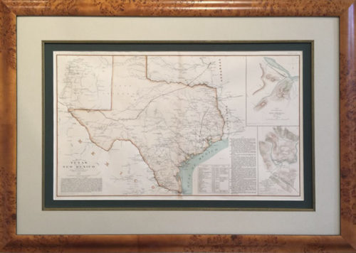
The full extent of the Independent and Sovereign Republic of Texas is shown as recognized by the United States, France, England and other major world powers. The western border of Texas is accurately depicted as being the Rio Grande River to its source, a claim established by the treaty Santa Anna signed after his defeat at the battle of San Jacinto. A vast independent Texas stretches all the way to the Rocky Mountains.
Several important early Texas towns are noted such as San Felipe De Austin, which was the site on the Brazos River chosen as the headquarters for Stephen F. Austin’s Colony. Early wagon roads are depicted, most importantly the El Camino Real, known as the King’s Highway or Old San Antonio Road, which ran from Natchitoches, Louisiana through Nacogdoches, Trinidad, Mina (present day Bastrop) and San Antonio de Bexar in Texas and on to Laredo and Monterey, Mexico. It originally served as a lifeline for the missions by enabling the transport of freight, supplies and military protection as well as facilitating trade. The road provided a vital artery for travel to the Texas. A once important early Mexican town and fort Tenoxtitlan, the Indian name for Mexico City, is marked near present day Burleson County just up the Brazos River from Austin’s colony. The historic settlement was established in 1830 at a strategic central point on the river just north of the halfway point of the Old San Antonio road. With such an advantageous location it was twice proposed as the capital of Texas. Descriptions for early explorers to Texas are also included on this fine map including Indian tribes like the Apaches and Cumanches as well as the Spanish forts in West Texas. Topographical details like rivers, lakes and mountain ranges as well as unique features like salt mines are shown.
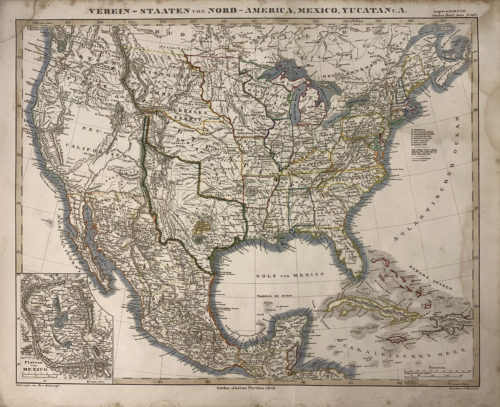
The entire west coast of the United States is ruled by Mexico and shown as Upper or New California. Missions, early forts and information contemporary to the discovery of gold are all included. Present Day California is shown as an island. The content in Old Mexico is excellent with a wealth of place names. This rare map is prized for its depth of content and exquisite detail, providing a captivating map window to the early days of what would soon become the legendary American Southwest.