Original Map of the Republic of Texas, circa 1845
with early counties
approximately 15″ wide x 13″ tall”
Contact the gallery for preferred pricing and details on our custom archival framing services for fine original maps and documents.
$1,400.00
Original Map of the Republic of Texas, circa 1845
with early counties
approximately 15″ wide x 13″ tall”
Contact the gallery for preferred pricing and details on our custom archival framing services for fine original maps and documents.
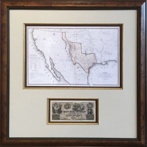
This detailed map provides a captivating portrait of the Independent Republic of Texas on the eve of joining the United States and becoming the 28th State. Scores of towns, cities and counties are shown particularly in the more populous south east portion of the country. Austin, resting along the Colorado River, is marked as the Capital of Texas. The site of the legendary battle of San Jacinto, where the Texans defeated the dictator Santa Anna and won their Independence in 1836, is clearly marked in Harris County. Many lesser known and once important settlements particularly along the Texas Coast are noted such as Austinia on the west bank of Galveston Bay that was originally developed by Stephen F. Austin’s nephew. The yet to be fully developed areas of Texas consist of the large Robertson and Milam counties in the North, San Patricio County in the South and the massive Bexar County dominating most of the West. Various Indian tribes are noted especially across the vast western stretches of Texas. A notation in the northwest mentions an 1833 exploration describing the tract of country as naturally fertile, well wooded and with a fair portion of water.
Interesting descriptions for settlers such as Extensive Prairies stretching across the north central region and the cross timbers, a naturally wooded barrier, in present day DFW area are shown. The Old San Antonio road, an early network of trails and trade routes developed by Native Americans and Spanish Explorers is marked running through San Antonio de Bexar and Fort Alamo – connecting Texas to Mexico and Louisiana. This early rare edition includes an inset of Texas North of the Red River showing the full extent of the Republic with Taos and New Mexico as part of Texas. The panhandle is home to the summer range of the Comanches. Rivers are marked across the country as well as Mountains, Forts, Silver Mines, Salt Lakes and other unique features which called settlers to the explore the vast rich lands of Texas. This fine map is window to the last days of the iconic Independent Republic of Texas before it became one of the most vital and popular states to join the US appealing to ambitious settlers from far and wide.
Our framed selections are individually hand-crafted to order. As such please allow approximately two weeks for most items to ship. Please call (512) 472-7701 or email li**@ga******************.com to discuss in-stock items or expedited availability.
We can ship selections all over the world, usually by FedEx. Everything is expertly packed and fully insured. FedEx charges vary depending upon distance, package size and shipping speed; please call or email us for specifics.
Generally, the shipping cost of a full scale flag runs between $45–$75. Most other framed items, including collector size flags and map replicas can be shipped for about $35.
As often as possible within Texas we try to deliver your order on our truck. This is especially true if you are getting several items at once.
We usually visit Houston, Dallas and San Antonio every couple of weeks, and special deliveries can be arranged as needed. It is our pleasure to try and personally deliver within Texas when possible.
FREE SHIPPING ● Give us a call (512) 472-7701 ● Send us a note lisa@galleryoftherepublic.comJoin our quarterly newsletter and receive special offers! We’d like to introduce you to the rich heritage of Texas! Dismiss