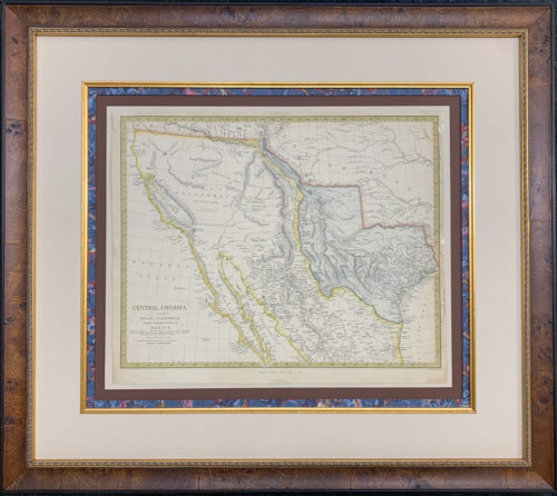
For nine years Texas was an independent nation – appearing as such on maps from, the era. This is one of less than three examples, however, that names Texas as a Republic on the face of the map itself. The crucial test for any nation declaring itself as sovereign is recognition by the world powers of the era as a legitimate government. This fine map, published in Scotland, reflects the recognition of Texas by Queen Victoria and the United Kingdom, which had strong interest in Texas as a new source of cotton for the English mills.
Interestingly though, this map conforms to the Mexican position of the scope of an Independent Texas… which was limited to the original Land Grants issued by the Spanish Crown and the Government of Mexico, the southwestern border of which was the Nueces River. The colonial capital of Texas – San Felipe de Austin, is noted as well as several other settlements, including Harrisburg, which grew into what we know now as Houston. Clearly shown is the El Camino Real or the “King’s Road” which was the sole land route linking Texas to French (and later) American Louisiana and then south to the wagon roads that led to the distant capital of Mexico City.
A wealth of information is detailed “back East” including roads, canals and proposed rail lines as well as the Natchez Trace and great National Road that ran east from St. Louis. Several state capitals are recorded that were subsequently changed: Milledegeville (GA) Vandalia (IL) and Cahawba (AL) and Arkopolis, renamed Little Rock, which was the capital of the Arkansas Territory, shown here in it’s rarest configuration on the eve of the establishment of the Indian Territory to the West.
The virtually endless prairies of the Great Plains are recorded as “Great Desert” since the early explorers equated trees with soil fertility. The empire of wheat and corn would later be established making the Great Plains one of the premier agriculturally productive areas in the entire world.