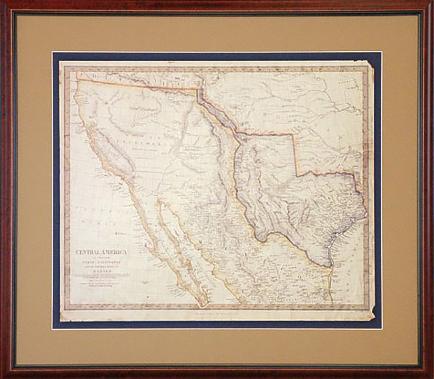
Circa 1843 by John Arrowsmith
$220 framed replica map in darkwood, 31″ x 28″
$220.00
Circa 1843 by John Arrowsmith
$220 framed replica map in darkwood, 31″ x 28″
This replica of the rare antique map published in London by John Arrowsmith, is one of the cornerstones of any Texas map collection. This map accurately reflects the western border of Texas as being the Rio Grande River to its source, a claim established by the treaty signed by Santa Anna after his defeat at the battle of San Jacinto.
At the time of publication these maps reflected the cutting edge of information about the rapidly growing country, which had been officially recognized by the United Kingdom in November of 1840 as a sovereign government. The early land grants which had been established under Mexican rule were being rapidly transformed into the first counties.
This map shows the earliest wagon roads and the El Camino Real, or Old San Antonio Road, which ran from the French trading posts on the Red River to Nacogdoches and then down through East Texas to San Antonio de Bexar and on into Old Mexico. Rivers and topographic details, including the Cross Timbers, a natural barrier that would protect the Dallas area from roving bands of Comanche, are clearly marked.
In addition an inset provides details of Galveston Bay, which was the key for both commerce and immigration, as it was far easier to sail along the coast from New Orleans to the booming southeast corner of Texas than it was to arrive overland. Interestingly, the location of a cotton gin opposite Morgan’s Point is marked, which would have been one of the first in service.
Throughout Texas, and in the lands to the north, the territories of various Indian tribes are noted, and the western segment of the Santa Fe Trail is also recorded. In the panhandle, a large area is marked off, with the notation of a supposed survey in 1833 by Le Grand, who reported that the entire area, which included most of eastern New Mexico and the Texas panhandle, as being: “naturally fertile, well wooded and with a fair proportion of water” in an effort to support a land development scheme to lure settlers to the area.
Our framed selections are individually hand-crafted to order. As such please allow approximately two weeks for most items to ship. Please call (512) 472-7701 or email li**@ga******************.com to discuss in-stock items or expedited availability.
We can ship selections all over the world, usually by FedEx. Everything is expertly packed and fully insured. FedEx charges vary depending upon distance, package size and shipping speed; please call or email us for specifics.
Generally, the shipping cost of a full scale flag runs between $45–$75. Most other framed items, including collector size flags and map replicas can be shipped for about $35.
As often as possible within Texas we try to deliver your order on our truck. This is especially true if you are getting several items at once.
We usually visit Houston, Dallas and San Antonio every couple of weeks, and special deliveries can be arranged as needed. It is our pleasure to try and personally deliver within Texas when possible.
FREE SHIPPING ● Give us a call (512) 472-7701 ● Send us a note lisa@galleryoftherepublic.comJoin our quarterly newsletter and receive special offers! We’d like to introduce you to the rich heritage of Texas! Dismiss